Cesium Chinese Website: http://cesiumcn.org/ | China Fast Access: http://cesium.coinidea.com/
Cesium makes it easier for first responders and military operators to quickly assess and understand dense and evolving urban environments.
Cesium supports visualization at any scale, from global down to sub-centimeter. We recently improved support for underground visualization, allowing exploration of underground environments to be seamlessly integrated with above-ground data.
Recently, we put these capabilities to the test in the Dense Urban Online Challenge, organized by the Department of Defense’s National Security Innovation Network (NSIN), aimed at addressing problems faced by first responders and military operators working in high-density cities with complex underground structures.
For this challenge, we partnered with Kaarta to demonstrate how Cesium can power numerous applications to solve these operational problems by bringing all data together and visualizing it, providing decision-makers with the information and insights they need.

A section of New York City’s East Side Access tunnel, captured by Kaarta.
At the hackathon, we demonstrated New York City tunnels collected by Kaarta’s mobile 3D scanners. These point clouds were captured with their handheld device, simply by walking through the tunnel, with laser precision within 3 centimeters. The generated point cloud was tiled and geolocated using Cesium ion.
The value here is that these precise 3D scans can be captured quickly and frequently, so you can have a map that’s always up to date, even for projects under active development, like the East Side Access transit tunnel in New York City. For first responders and military operators, up-to-date maps of these dense environments are critical for decision-making.
Since devices like these make near real-time high-resolution scanning possible, with Cesium you can combine these scans to see how all projects in any given area are developing simultaneously. By combining with other datasets, it’s easy to plan for potential conflicts – for example, by overlaying maps of the sewer system to ensure it doesn’t get too close. With Cesium’s measurement tools, these analyses are simple and comprehensive.
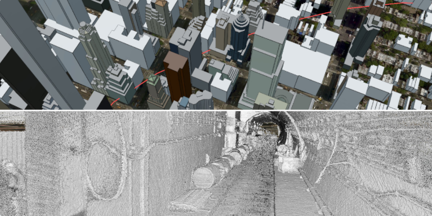
Top: Ground-level view of New York City with tunnel locations marked in red. Bottom: Interior view of the tunnel.
Out of 31 teams that participated in the NSIN Dense Urban Online Challenge, we were one of 5 teams selected for the in-person hackathon. We’re excited to provide a platform that enables others to solve these complex challenges. If you’re doing underground work, or if you’re interested in Cesium for defense, please contact brady@cesium.com.
Original link: https://cesium.com/blog/2020/08/25/national-security-hackathon/
Author: Brady Moore
Comment: Quite impressive.
Cesium Chinese Website QQ Group: 807482793
Cesium Chinese Website: http://cesiumcn.org/ | China Fast Access: http://cesium.coinidea.com/